01
See the work before you contract
Send 25-50 representative frames. We label them at our cost, return the output and a per-class QA scorecard. You decide whether to scope a pilot after you have seen the labels, not before.
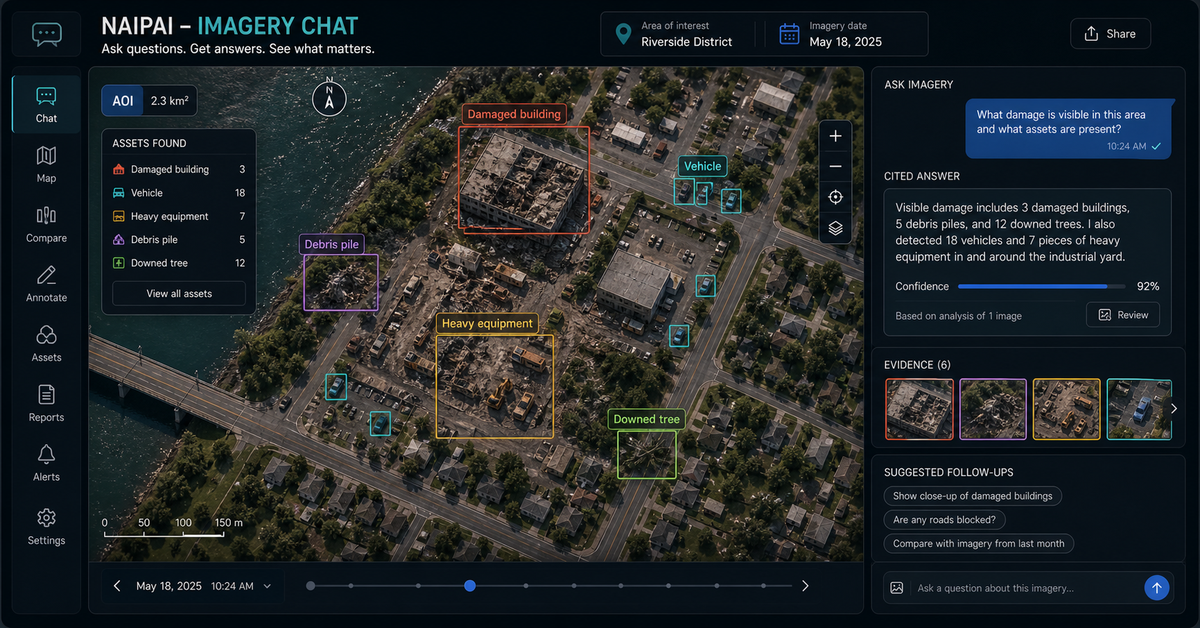
Anchored in the NAIPAI pattern: ask aerial, drone, or satellite imagery useful questions, keep confidence and caveats visible, and turn answers into map layers, reports, APIs, or analyst review queues.
Send 25-50 representative frames. We label them at our cost, return the output and a per-class QA scorecard. You decide whether to scope a pilot after you have seen the labels, not before.
Bill per labeled object when scope and volume are predictable. Bill per labeling hour when the workflow is exploratory or the schema is still firming up. Both models are on the table from the first scoping call.
We operate in CVAT, Labelbox, Roboflow, V7, Scale AI workflows, and most in-house labeling stacks. No platform migration on your end. If you have a custom tool, we learn it on the pilot.
On infrastructure asset classes, validated per delivery
Bounding boxes, segmentation masks, and point labels for road signs, utility poles, manholes, and street furniture.
Multi-spectral analysis from Landsat, Sentinel, Planet, and UAV captures — feature extraction with sub-meter precision.
Panel detection, rooftop segmentation, and vegetation encroachment from satellite and drone imagery.
Spatial validation, coordinate accuracy checks, and classification QA against authoritative GIS databases.
Deploy trained models into production pipelines with TensorFlow, PyTorch, and cloud-native inference.
GeoAI implementation, imagery chat, remote sensing AI workflow, satellite imagery analysis, and aerial image assistant.
Ask what changed, where damage appears likely, and which parcels or assets need field review first.
Count solar panels, tanks, equipment yards, vehicles, utility features, or visible site assets from imagery.
Convert repetitive visual review into answer schemas, confidence cues, QA checklists, and exportable notes.
Bring the closest real workflow. We map what you send, what your team reviews, what evidence stays visible, and what you receive at handoff.
A sample image set and the 3-5 questions your team asks repeatedly.
We configure model behavior, answer structure, confidence cues, evidence panels, exports, and user path.
Each answer shows what was found, how confident it is, what needs review, and what data was used.
Private demo, embedded app, API endpoint, analyst dashboard, map layer, or client-ready report workflow.
Answers should include confidence, caveats, and human review points.
Imagery assistants should not hide uncertainty or replace field confirmation where required.
NAIP, Sentinel, Landsat, drone orthomosaics, inspection photos, thermal, multispectral, and customer archives.
Prompt rules, answer schema, confidence language, examples, thresholds, and reviewer workflow.
Map layer, report, ticket, CSV, GeoJSON, dashboard card, API response, or analyst queue.
No vague discovery phase. You bring four or five things, we return a specific plan you can evaluate.
Every class has a labeled definition, edge-case examples, and QA rules calibrated against authoritative GIS databases. Add custom classes during pilot and we extend the taxonomy.
Every label is a complete GeoJSON feature with geometry, class, confidence, QA trail, and source provenance. Loads directly into your map, your trainer, or your validator — no conversion script.
{
  "type": "Feature",
  "geometry": {
    "type": "Polygon",
    "coordinates": [[[ -77.0364, 38.8951 ], ...]]
  },
  "properties": {
    "class": "crosswalk",
    "class_id": "CW_001",
    "mutcd_type": "continental",
    "confidence": 0.97,
    "qa_status": "approved",
    "qa_reviewer": "annotator_03",
    "qa_timestamp": "2024-08-15T14:23:17Z",
    "source_frame": "frame_847.jpg",
    "capture_timestamp": "2024-08-12T11:18:04-04:00",
    "schema_version": "gss-roads-v2.4"
  }
}No open-ended retainers. No "discovery phases" that bill for months without producing anything you can evaluate.
50-100 frames, your schema, your edge cases. We return a calibration set so you can see how we interpret your taxonomy before scale.
500 samples in 2-4 business days. Inter-annotator agreement scores, QA dashboard, format in your pipeline (GeoJSON, COCO, KITTI, Mapillary).
Production volume with SLA. 24/7 follow-the-sun capacity, 98%+ QA target, weekly delivery cadence.
Wire into your training pipeline, deploy custom validation rules, build out edge case mining. Optional embedded team.
These open the real, interactive demos on our main site — not screenshots, not videos. Click around before you decide to talk to us.
Both. We can deliver labeled datasets alone, or build the model on top — TensorFlow, PyTorch, or your team's framework — and integrate it into your inference pipeline.
Object detection (bounding box and segmentation) for street assets, semantic segmentation for land use and pavement, change detection for satellite imagery, and graph neural networks for routing and network analysis.
Depends on your need. Edge inference (on-device) for field workflows, batch inference on cloud for archive processing, or real-time serving via Cloud Run / Lambda / SageMaker for production pipelines.
Monthly retraining on accumulated data with automatic drift detection — we surface accuracy degradation before it shows up in operations. Ship a model card with every release so you can audit performance over time.
We transform satellite imagery, drone captures, LiDAR point clouds, GIS vectors, and change-detection scenes i…
Send a representative sample, lock the taxonomy, review calibration labels, and get a small delivery package b…
Production annotation teams for infrastructure AI, remote sensing, mobile mapping, and GIS data programs, with…
Dispatch optimization, container tracking, and demand prediction built for roll-off dumpster companies — runni…
No purchase order, no master service agreement. Send a representative slice and a target schema; we return the labels in the format your pipeline already ingests.
Scope an imagery assistant or GeoAI pilot